August 6, 2024
Reading time: 1 minute(s)
Making polylines from input points
Reading time: 1 minute(s)
Convert point features to one or multiple polylines.
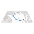
The XTools Pro Polylines from Points tool allows users to create new polylines from input point features.
Users can group or order input points by specifying the names of input attribute fields into the parameters. These parameters determine how the points are clustered into polylines.
An additional option available in this tool is the ability to close the output polylines. This is useful for creating boundary lines or enclosing areas.
The Polylines from Points tool is a powerful feature applicable to a wide range of specific tasks across different fields. Here are some notable applications:
- The tool can be used to map road networks by connecting survey points that represent the start, end, and intermediate points of roads. It helps urban planners in designing and visualizing transportation infrastructure.
- By converting points that mark the locations of utility infrastructure (such as power lines, water pipelines, and communication cables) into polylines, utility companies can better manage and plan their networks.
- Environmental scientists can use this tool to create accurate maps of rivers and streams from GPS points collected along the watercourse. This is essential for hydrological studies and watershed management.
- In wildlife conservation, tracking the movement of animals through GPS collars allows researchers to map migration paths by converting the location points into continuous polylines.
- Mapping ancient routes or pathways by connecting points of interest helps in preserving and studying historical sites.
