August 5, 2024
Reading time: 1 minute(s)
Converting features to points
Reading time: 1 minute(s)
Convert polygon and polyline features to points with customizable options.
The XTools Pro Features to Points tool for converting polygon and polyline features to points is designed to facilitate spatial data manipulation by transforming complex geometries into simpler point datasets.
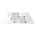
Users need to define which specific points or nodes of the input features will be converted:
- All - all points (nodes) forming input features.
- Start - only start points.
- End - only end points.
- Start and end - only start and end points.
- Center - only center points.
This flexibility allows control over the resulting point dataset, tailored to the specific needs of the analysis.
The Features to Points tool can be applied to various specific tasks across different fields that require spatial analysis and data manipulation:
- converting utility lines and infrastructure boundaries (like water pipes, power lines, or road networks) into point datasets helps in tracking individual assets, scheduling maintenance, and managing repairs;
- identifying key points such as start and end nodes of pipelines or power lines allows to facilitate regular inspections and ensure system integrity;
- converting habitat boundaries into points provides better managing wildlife movement patterns and population distributions;
- mapping the central points of affected areas is useful for rapid assessment and response during disasters such as hurricanes, earthquakes, or fires.
