Creating rectangular fishnet grids
Create a dataset containing a net of rectangular cells covering a specified area.
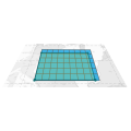
The XTools Pro Create Rectangular Fishnet tool creates grids of rectangular cells over a specified area.
Users can specify the number of rows and columns or the height and width of the cells in selected units. This flexibility ensures that the grid can be fit various analytical needs.
Besides, the tool offers options for rotating output cells as well as the entire fishnet. Both rotation parameters can be set to positive or negative values, allowing for clockwise or counterclockwise adjustments. It can be useful for aligning the grid with specific features in your data.
Extent for creating the fishnet can be specified as one or several hand-drawn rectangles. So, the tool includes an option to split the output fishnet by multiple rectangles, enabling the creation of intersecting grids.
The Create Rectangular Fishnet tool is essential for tasks such as environmental monitoring, urban planning, and resource management, where spatial data needs to be systematically divided for detailed analysis.
Here are some specific tasks where this tool can be effectively utilized:
- The tool can create grids to systematically survey and monitor wildlife habitats. By overlaying a fishnet grid on a study area, researchers can assess the distribution of species, identify critical habitats, and analyze changes over time.
- Creating a fishnet allows environmental scientists to divide an area into manageable units for studying the dispersion of pollutants in air, water, or soil. It helps in pointing pollution sources and understanding their impact on different regions.
- Planners can use the tool to create a fishnet overlay to divide a city or region into smaller zones for detailed land use analysis. It aids planning urban development, infrastructure placement, and zoning regulations.
- By creating a fishnet grid over urban areas, demographers can analyze population density and distribution. This information is crucial for urban planning, resource allocation, and public service provision.
- In agriculture, the tool can be used to divide farmland into smaller units for crop rotation planning, soil analysis, and irrigation management. It helps farmers optimize land use and improve crop yields.
