Creating hexagonal fishnet grids
Create a dataset containing a net of hexagonal cells covering a specified area.
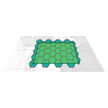
The XTools Pro Create Hexagonal Fishnet tool creates grids of hexagons over a specified area.
Users can specify one of three parameters to adjust the size of the hexagonal cells in the selected units: the cell's edge length, the radius of an inscribed circle, or the cell's area. It allows for precise control over the dimensions of the hexagonal cells, ensuring that the fishnet can be tailored to meet specific analytical requirements.
Besides, the tool offers options for rotating output cells. The rotation angle can be set to positive or negative value, allowing for clockwise or counterclockwise adjustment. It can be useful for aligning the grid with specific features in your data.
Extent for creating the fishnet can be specified as one or several hand-drawn rectangles. So, the tool includes an option to split the output fishnet by multiple rectangles, enabling the creation of intersecting grids.
Here are some specific tasks where the hexagonal fishnet can be effectively applied:
- Hexagonal grids are ideal for studying species distribution and biodiversity. They provide a more natural and contiguous representation of habitats, reducing edge effects compared to rectangular grids. That makes it easier to assess population densities and habitat connectivity.
- Hexagonal grids can be used to study urban heat islands by providing a uniform spatial framework for temperature data collection. It helps in identifying hotspots and planning cooling strategies more effectively.
- Hydrologists can use hexagonal grids to model watersheds and analyze water flow patterns. Hexagons reduce the directional bias that can occur with rectangular grids, providing more accurate hydrological models.
- The tool can create hexagonal grids to map wildfire risk areas. That aids the identification of high-risk zones and planning of mitigation measures such as controlled burns and firebreaks.
