July 29, 2024
Reading time: 2 minute(s)
Building hulls around features
Reading time: 2 minute(s)
Build convex and detailed concave hulls for features of any geometry type.
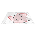
The XTools Pro Concave Hull tool creates polygons that fit around a set of input features. The tool creates a boundary that adheres more closely to the actual distribution of features. However, it can make a convex hull just bounding all features.
The Concave Hull tool provides the following capabilities:
- Creating detailed hulls
Users can specify Level of detail parameter to more than 0% to control how closely the output hull follows the input features. At 100%, it encloses input data with the smallest area. - Creating multiple hulls
Users can create multiple hulls by grouping the data by the attribute field. This is beneficial when dealing with heterogeneous datasets where different clusters of features need individual boundaries. - Creating holes inside the hulls
Users can allow the tool to create holes within the output hull, which is useful when the input features are arranged in such a way that empty spaces within the output hull need to be excluded for more detailed shapes.
Here are some specific tasks where the Concave Hull tool can be effectively applied:
- delineating the boundaries of animal habitats or home ranges based on tracking data points. It creates more realistic and accurate representations of the areas animals use, which is essential for conservation planning and habitat management.
- mapping the boundaries of specific vegetation types or plant communities from sampled point data. It helps in assessing the spatial distribution of vegetation and planning conservation projects.
- defining the precise boundaries of infrastructure projects, such as parks, residential areas, or industrial zones, based on survey points. It ensures accurate planning and development, minimizing conflicts and optimizing land use.
- creating precise boundaries around archaeological sites based on excavation or survey points. It helps in protecting and managing archaeological resources, ensuring that development or conservation efforts are appropriately targeted.
- building clusters of data points, such as crime incidents or disease outbreaks. It aids identifying patterns and trends, facilitating targeted interventions and resource allocation.
