August 7, 2024
Reading time: 1 minute(s)
Building buffer zones around features
Reading time: 1 minute(s)
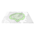
Create buffer polygonal areas around input features of any geometry type to a specified distance.
The XTools Pro Buffer Tool builds buffer polygons around input features. Users can input a positive distance in selected units to create an outward buffer or a negative value for inward buffers, particularly for polygon features.
This tool is particularly useful for tasks such as environmental impact studies, urban planning, and resource management, where understanding the spatial relationship between features and their surrounding areas is critical:
- creating buffer zones around sensitive habitats or endangered species locations to ensure protective measures are in place and human activities are regulated within these zones;
- identifying areas that fall within a certain distance from pollution sources, such as factories or landfills, to assess potential environmental impacts and develop mitigation strategies;
- planning the development of infrastructure projects such as roads, railways, and utilities by creating buffers to analyze the impact on surrounding areas and ensure proper zoning;
- defining zones of influence around public amenities like schools, parks, and hospitals to guide urban development and ensure access for residents;
- establishing buffer zones around hazard-prone areas, such as floodplains, earthquake fault lines, or wildfire-prone regions, to aid risk assessment and emergency planning;
- creating buffers around critical infrastructure and populated areas to plan and design evacuation routes and safe zones during emergencies;
- designing buffer strips around agricultural fields to prevent soil erosion, manage water runoff, and protect water bodies from agricultural pollutants.
