July 2, 2024
Reading time: 2 minute(s)
Adding X, Y, and Z coordinates
Reading time: 2 minute(s)
Add X, Y, Z coordinates, latitude and longitude, to your spatial data (locations, directions, areas) as attributes.
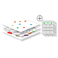
The XTools Pro Add XYZ Coordinates tool adds precise X, Y, and Z coordinates to input features. The tool supports various coordinate systems and angular units formats, allowing users to accurately locate their data points. It enables further analysis and visualization in GIS environments.
Coordinates are added to attribute tables of points, multipoints, lines, and polygons:
- For points, the tool adds X, Y, and Z coordinates for all features.
- For multipoints, the tool adds X, Y, and Z coordinates for a virtual Center point or real Nearest to center point of all features.
- For lines, the tool adds X, Y, and Z coordinates of the user-defined line point (Start, End, or Center) for all features.
- For polygons, the tool adds X and Y coordinates for a Center or Label point of all features. Label points are always taken inside polygons.
Users can view added fields with coordinates when opening the output attribute table after the tool is finished.
The Add XYZ Coordinates tool can be effectively applied:
- Surveyors can use the tool to add precise X, Y, and Z coordinates to surveyed points, ensuring that the data aligns correctly with geographic reference systems. This is crucial for creating accurate maps and plans for construction, land division, and infrastructure development.
- Environmental scientists can add X, Y, and Z coordinates to field data collected from different locations to monitor changes in ecosystems, track the movement of species, or study the impact of environmental phenomena such as erosion or deforestation.
- Geologists can enhance their spatial datasets by adding X, Y, and Z coordinates to points representing rock samples, fault lines, or mineral deposits. It aids the analysis of geological formations and resource exploration.
- Urban planners and infrastructure managers can use the tool to add precise location data to assets such as utility poles, fire hydrants, and streetlights. This information supports asset management, maintenance scheduling, and service optimization.
- In aviation and maritime sectors, adding X, Y, and Z coordinates to navigation aids, such as buoys, beacons, and waypoints, ensures precise navigation and enhances safety in navigation and route planning.
- Archaeologists can add X, Y, and Z coordinates to artifacts, excavation points, and site features. It facilitates the accurate documentation, analysis, and preservation of archaeological sites.
- Adding precise location data to heritage sites and monuments helps in managing and protecting cultural assets, supporting conservation efforts and promoting heritage tourism.
